


Bright Star Precinct, Miller County, Arkansas
About
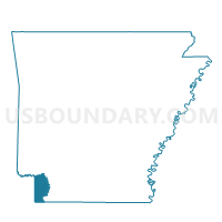
Outline

Summary
| Unique Area Identifier | 527302 |
| Name | Bright Star Precinct |
| County | Miller County |
| State | Arkansas |
| Area (square miles) | 84.85 |
| Land Area (square miles) | 83.70 |
| Water Area (square miles) | 1.16 |
| % of Land Area | 98.64 |
| % of Water Area | 1.36 |
| Latitude of the Internal Point | 33.14330700 |
| Longtitude of the Internal Point | -93.97743020 |
Maps


Graphs
Select a template below for downloading or customizing gragh for Bright Star Precinct, Miller County, Arkansas


Neighbors
Neighoring Voting District (by Name) Neighboring Voting District on the Map
- Voting District 0012, Cass County, TX
- Voting District 0014, Cass County, TX
- Voting District 0016, Cass County, TX
- Voting District 0018, Cass County, TX
- Voting District 008C, Bowie County, TX
- Doddridge Precinct, Miller County, AR
- Fort Lynn Precinct, Miller County, AR
- Fouke Precinct, Miller County, AR
- Pleasant Hill Precinct, Miller County, AR
- Precinct 146, Caddo Parish, LA
- Precinct 149, Caddo Parish, LA
Top 10 Neighboring County Subdivision (by Population) Neighboring County Subdivision on the Map
- District 1, Caddo Parish, LA (20,040)
- Atlanta CCD, Cass County, TX (13,705)
- Maud-Redwater CCD, Bowie County, TX (10,221)
- Beech township, Miller County, AR (3,773)
- Sulphur township, Miller County, AR (1,496)
- Days Creek township, Miller County, AR (1,032)
Top 10 Neighboring Unified School District (by Population) Neighboring Unified School District on the Map
- Caddo Parish School District, LA (254,969)
- Texarkana School District, AR (32,645)
- Liberty-Eylau Independent School District, TX (14,674)
- Atlanta Independent School District, TX (10,518)
- Fouke School District, AR (5,782)
- Queen City Independent School District, TX (5,196)
- Bloomburg Independent School District, TX (1,374)
Top 10 Neighboring State Legislative District Lower Chamber (by Population) Neighboring State Legislative District Lower Chamber on the Map
- State House District 1, TX (146,509)
- State House District 1, LA (44,917)
- State House District 2, AR (25,839)
- State House District 4, AR (25,193)
Top 10 Neighboring State Legislative District Upper Chamber (by Population) Neighboring State Legislative District Upper Chamber on the Map
- State Senate District 1, TX (731,108)
- State Senate District 39, LA (107,940)
- State Senate District 21, AR (74,633)
Top 10 Neighboring 111th Congressional District (by Population) Neighboring 111th Congressional District on the Map
- Congressional District 4, TX (846,142)
- Congressional District 1, TX (723,464)
- Congressional District 4, LA (667,109)
- Congressional District 4, AR (654,283)
Top 10 Neighboring Census Tract (by Population) Neighboring Census Tract on the Map
- Census Tract 210, Miller County, AR (8,063)
- Census Tract 114.01, Bowie County, TX (7,944)
- Census Tract 9501, Cass County, TX (6,621)
- Census Tract 251, Caddo Parish, LA (2,048)
Top 10 Neighboring 5-Digit ZIP Code Tabulation Area (by Population) Neighboring 5-Digit ZIP Code Tabulation Area on the Map
- 71854, AR (36,438)
- 75501, TX (36,298)
- 75551, TX (11,007)
- 71837, AR (5,227)
- 71834, AR (1,491)
- 75556, TX (1,133)
- 71069, LA (812)
- 71044, LA (657)